Escambray Massif
Escambray Massif
Cuba's second mountain range, Escambray unfolds waterfalls, trails and revolutionary heritage just 30 minutes from Trinidad.
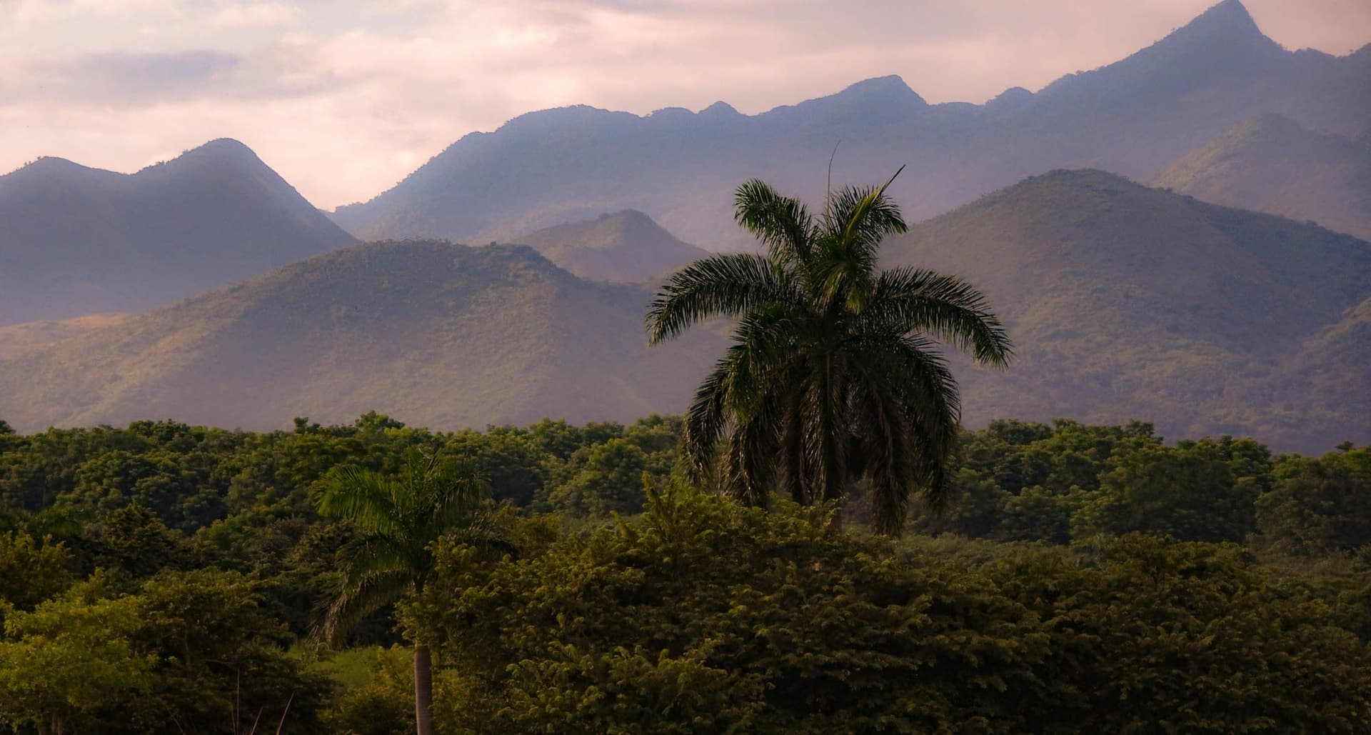
In central Cuba, the Sierra del Escambray (sometimes called Escambray mountains) sprawls across verdant relief, rivers, limestone caves and coffee-growing villages between the provinces of Cienfuegos, Villa Clara and Sancti Spiritus. Cuba's second-largest mountain range after the Sierra Maestra, it stands as a premier natural and historical stopover, just thirty minutes from Trinidad.
Why visit the Escambray Massif
Escambray combines three assets rarely found together elsewhere in Cuba: genuinely mountainous terrain peaking at 1,140 meters, dense recent history (from Che Guevara's guerrilla campaigns to peasant rebellion in the 1960s) and a mosaic of protected ecosystems. For those departing Havana or Varadero, it also offers a change of pace: cooler mountain air, forest trails, waterfalls and coffee plantations replace the beach atmosphere.
Immediate proximity to Trinidad, a UNESCO-listed colonial town, and the Valle de los Ingenios at the massif's southeastern base allows you to easily combine heritage and nature over two to three days.
Geography of the massif
The massif stretches roughly 80 km long with an area of nearly 600 km². The highest point, Pico San Juan, reaches 1,140 meters. Several other summits structure the terrain: Caballete de Casas, Gavilanes, Loma de Banao, Caja de Agua and Pico Tuerto. Pico Potrerillo (930 m), 5 km from Trinidad, is among the most accessible.
The Agabama River divides the whole into two entities: the Guamuhaya mountains to the west, which concentrate most tourist activity, and the Sierra de Sancti Spiritus to the east, more secluded. Lake Hanabanilla, Cuba's only mountain lake, completes this landscape.
Flora is dense and varied: giant ferns, cedars, wild roses and species introduced since colonial times. As for fauna, you'll encounter hummingbirds, tocororos (Cuba's national bird) and several endemic lizard species.
A history of resistance
Before 1492, the massif was called Guamuhaya, referencing the indigenous populations who inhabited it. This name remains used to designate the western portion of the mountains.
In the twentieth century, Escambray became central to Cuban history. During the Revolution, its slopes harbored camps of Che Guevara and his guerrillas. But between 1959 and 1965, the region was also the seat of the "Escambray rebellion": anti-Castro peasants waged armed struggle against the new regime. In 1961, after the failed Bay of Pigs invasion, a withdrawal of counter-revolutionaries toward the massif was considered but not executed.
This memory remains visible on the ground, notably at the Cueva de los Alambres, now a memorial site, and in several former camps repurposed.
What to see and do
Topes de Collantes and its waterfalls
The Topes de Collantes nature park, 20 km from Trinidad, is the massif's tourist heart. Access it via hiking to several waterfalls:
- Salto del Caburni: roughly 7 km round-trip hike, among the most demanding yet spectacular.
- El Nicho: the most accessible, with viewpoint, swimming pool and cave.
- Vegas Grande: less crowded, emerald-green waters.
- Salto El Rocio: in Guanayara park, 3 km hike.
The trails, called senderos, are marked but sometimes technical. Experienced hikers can combine Caburni and Vegas Grande on the same day.
Cultural stops
- Casa Museo del Café at Topes de Collantes, dedicated to coffee heritage.
- Contemporary art museum at Kurhotel Escambray.
- Hacienda Codina, with botanical gardens and mud baths.
- La Batata trail, leading to a cave sheltering an underground pool.
Complementary activities
- Horseback rides from local fincas.
- Zip-lines installed in several areas.
- Swimming in natural pools formed at waterfall bases.
- Visits to coffee plantations still in operation.
When to visit
The dry season, November through April, remains the most comfortable period: passable trails, reasonable water flow on waterfalls and pleasant mountain temperatures. From May to October, the wet season makes paths slippery and some trails may close temporarily after heavy rains, but vegetation is at its peak and waterfalls more impressive. Hurricane season (August-October) warrants weather monitoring.
Whatever the season, bring an extra layer: it's noticeably cooler than the lowlands, especially at sunrise and at altitude.
Practical information
- Recommended duration: minimum one day for Topes de Collantes, two to three days to explore multiple parks.
- Level: most hikes are accessible to a fit walker; some (Caburni) require endurance.
- Equipment: good-grip shoes, water, insect repellent, swimsuit for pools.
- Guides: recommended for longer trails, often mandatory in parks managed by Gaviota.
- Fees: paid entry to parks, moderate amounts; payable in Cuban pesos or currency depending on sites.
How to get there
The massif is easily accessible thanks to its central position:
- From Trinidad: roughly 30 minutes' drive to Topes de Collantes.
- From Cienfuegos: about 1 hour 30 minutes.
- From Santa Clara: access via the massif's northern section, less-traveled route.
Roads are passable but sometimes narrow and winding. Viazul long-distance bus doesn't serve the area. Three options are available:
- Car rental: most flexible for combining multiple sites.
- Guided tour from Trinidad or Cienfuegos, often by jeep or 4x4 truck.
- Private driver, usually arranged through your casa particular.
Combine with
- Trinidad, UNESCO colonial town, ideal base for the massif.
- The Valle de los Ingenios, former sugar center UNESCO-listed, at the massif's southeastern base.
- The Jagua Castle near Cienfuegos, heritage stop on the western route.
- The Bay of Pigs, another major landmark of recent Cuban history.
- The Caguanes National Park to extend the nature experience.
Frequently asked questions
Frequently asked questions
For short El Nicho trails or viewpoint walks, no. For Salto del Caburni, Vegas Grande or combined itineraries, a guide is strongly recommended: marking is sometimes irregular and terrain slippery in wet season. In certain Gaviota-managed parks, the guide is included with entry fee.
One day allows you to discover Topes de Collantes and one waterfall. To combine Caburni, El Nicho and a cultural site like Casa Museo del Café, allow two days with one night on-site or in Trinidad.
No. Viazul doesn't serve the area. You need a rental car, an organized tour from Trinidad or Cienfuegos, or a private driver.
November through April for hiking comfort. May through October, vegetation is denser and waterfalls more powerful, but you must contend with showers and hurricane season from August to October.
Variable depending on trails. El Nicho and La Batata are accessible to most walkers. Salto del Caburni (7 km round-trip with elevation) requires good physical condition.
Plan your trip
Escambray Massif naturally integrates into a circuit centered on Trinidad, Cienfuegos and the Valle de los Ingenios. To build a tailor-made itinerary including nature, revolutionary history and colonial towns, check out our trips to Cuba.
Interested in this visit?
We can include it in your personalised itinerary.